Wednesday, June 28, 2017

Operation IceBridge Spring campaign

For the past several years I joined the Operation IceBridge Alaska campaign. The primary goal for this NASA funded work is to measure glacier change with an airborne lidar. We also try to measure ice thickness with a radar, which is a tricky proposition, because the radar signals bounce of all the mountains and obscure the returns from the glacier bed.
Flying in the mountain always requires a lot of patience to wait for good weather. This spring was particularly windy and we could not fly for almost two weeks, because conditions were never quite right. But finally we completed a survey of Glacier Bay (I wasn't there for that), the Sargent and Harding Icefield, and the Eastern Alaska Range. Below are just a few impressions:
The calving front of Chenega Glacier in Prince William Sound with a small calving event caught in the act

Excelsior Glacier is a rapidly retreating outlet of the Sargent Icefield, calving big icebergs into a proglacial lake

Beautiful internal waves

Root and Kennicott Glacier with Mt. Blackburn

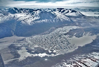
The Tana Glacier is also retreating rapidly with a proglacial lake that is getting bigger each year

Thursday, June 8, 2017

How deep is the Bagley Icevalley?

We have been trying to measure the depth of the Bagley Ice Valley for years, using airborne radar. But it has been an enigma; we suspected because of its depth. Temperate ice (ice at its freezing point) contains water and that makes it really difficult for radar waves to penetrate. We had a chance to do a survey on the ground with a very low frequency system and it looks like this was successful. We are still working on the data, but it looks like we've found ice that is more than 1500 m thick.

Deployment by Ultima Thule's Single Otter

The front half of the radar setup with antenna and a sled containing the receiver

How far is it to bedrock? Photo: Jack Holt

Pulling the radar across the glacier. Michael on the snowmachine and I'm being pulled on skis. Photo: J. Holt

Wednesday, June 7, 2017

Black Rapids Glacier

Every year in spring we make a trip to Black Rapids to do some mass balance measurements. Once again we found a beautiful day for it, and this time my daughter Sonja got to join me as well.

Surprisingly, Black Rapids Glacier had quite a low snow year; it was one of the thinnest snow covers we've measured in several decades. It's surprising, because Fairbanks had quite a nice year. In general, Black Rapids Glacier continues to thin rapidly.