Thursday, December 22, 2011

Still in McMurdo

On December 1 we arrived at McMurdo station, the primary hub for US Antarctic Program activities. And now it's nearly Christmas, and we're still here. Our whole program is about a month late.
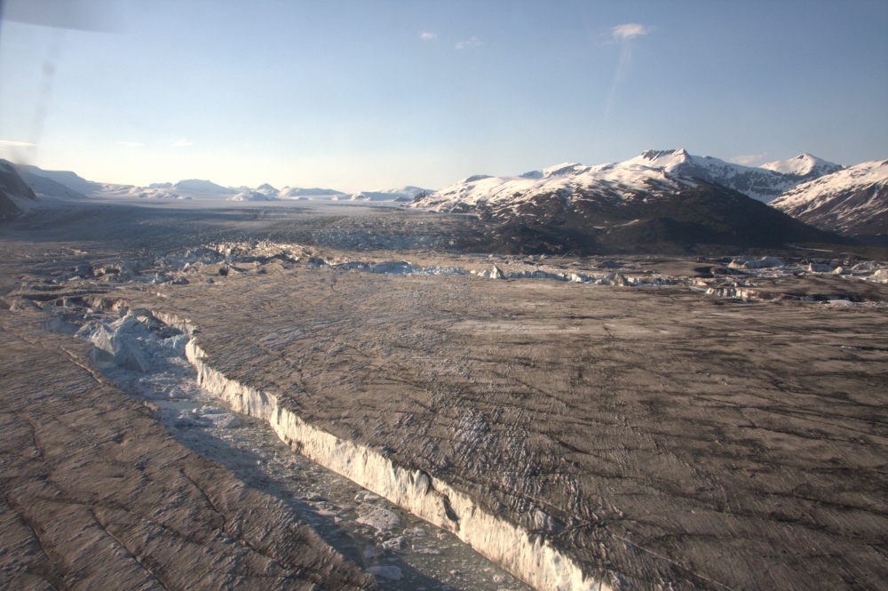
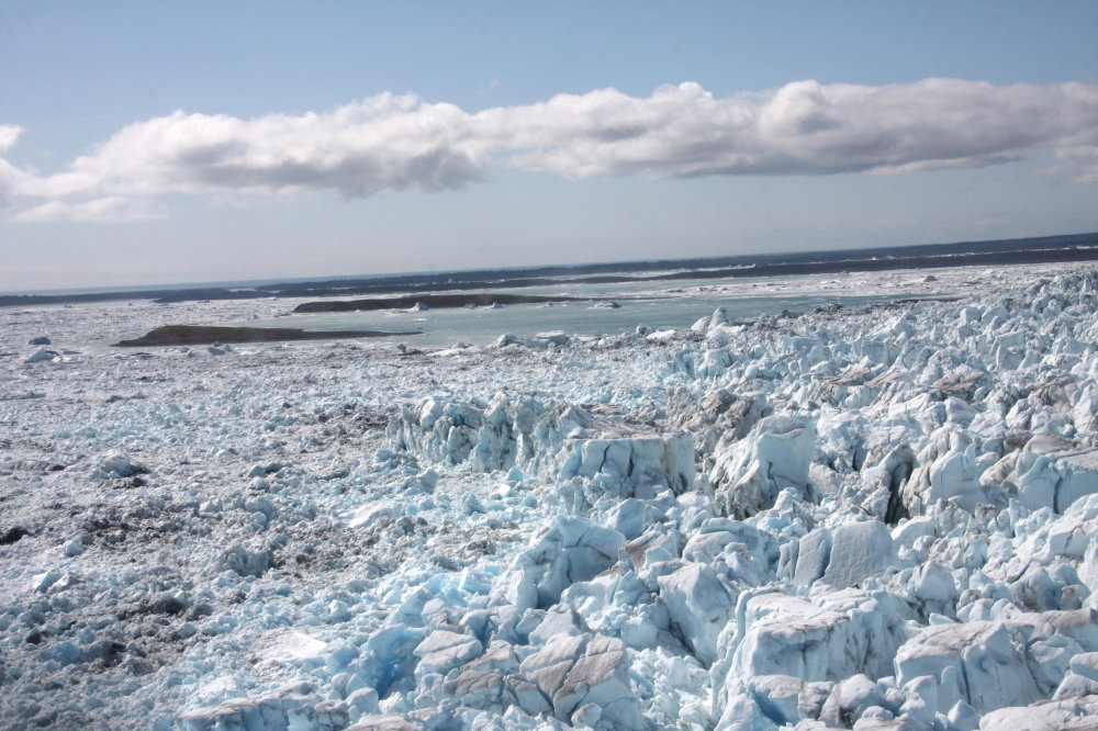
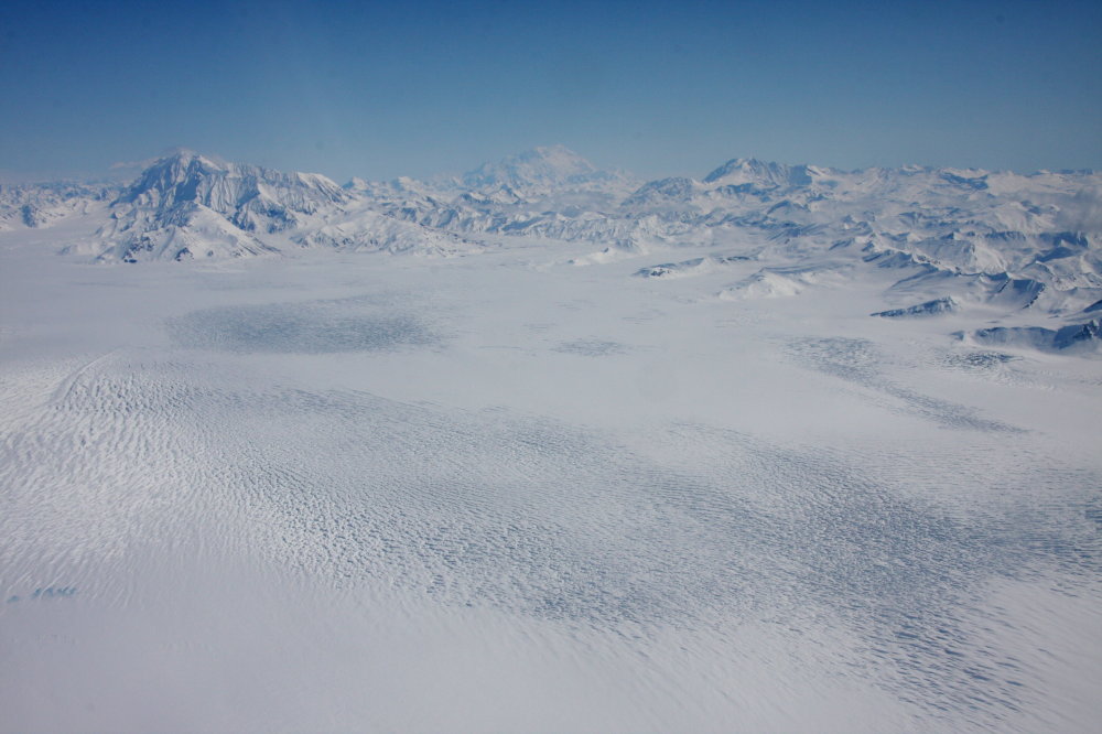
We came here to drill through the ice shelf at Pine Island Glacier. This is one of most rapidly changing glaciers on the planet and it is a big one. Much of the changes can be blamed on warm ocean water that is getting under a floating ice shelf and is melting it from below. We are planning to drill through it and then measure that process directly.
Getting out to PIG is not easy. The distance from McMurdo to the base camp exceeds 1500 miles (~2500 km). It is comparable to the distance from Seattle to Chicago (or Madrid to Oslo for the more European declined). Imagine moving a field party, a hot water drill and a lot of instrumentation across the coldest and windiest continent. Delays are inevitable, and bad weather, mechanical failures, and simply bad luck have all played a role.

Instead we are enjoying McMurdo. As much as I'd like to get out of here; it is an interesting town to explore. Its summer population is about 1,000 people. It could be like any small town in the Arctic, but one pretty quickly realizes that it's not the same. There are no kids, no elders, and no dogs. The town is entirely dedicated to supporting science and to a large degree to supporting the South Pole station.
The view above is from Observation Hill, a small volcanic cone above town. The small peninsula in the background is where Captain Scott set up winter quarters, just over 100 years ago. The hut can be seen in the picture below.

His bid for the South Pole ended tragically, and Scott and his men died on the way back from the pole, after having been beaten to the goal by the Norwegian explorer Amundson, who had already successfully completed the first navigation of the Northwest Passage in the Arctic (at least the first European navigation...). The 100 year anniversary of his arrival at the South Pole was commemorated last week. The Norwegian prime minister flew in for the occasion.
Scott's misfortunes are commemorated with a cross on Observation Hill. It was put up by surviving members who waited for his return in 1913.

McMurdo can be a nice place in beautiful weather. The mountain range across the sound (the Royal Society Range) is beautiful and beckons, but, alas, no heliskiing for us...
On the other side we are greeted by Mt. Erebus, one of Earth's most active volcanoes, and its southernmost. It always has a little puff cloud. Another set of nice looking slopes, but, again, off limits.
McMurdo is, of course, entirely dependent on outside support. This happens via ship (once a year) and via several airplanes during the Antarctic summer. Everything that was used gets shipped off the continent again and goes back to the US for proper disposal. In the process, there is a relatively elaborate waste separation program. Occasionally, somebody with a sense of humor enhances that program (see the one in the middle):
Under the cover of each recycling bin, one can find detailed instructions about what can and cannot be disposed of here:
One of the big challenges of McMurdo is energy. It is cold here and windy. Not so bad in the summer, right now temperatures are always around, but mostly above freezing. Almost the entire station runs on diesel that is shipped here. For the past two years, three wind turbines are operational. These mostly supply the neighboring Scott Station, which is operated by New Zealand, but some excess power comes to McMurdo.
Scott Station:
And to finish of: A picture of our team member Dale Pomraning (hot water driller) doing some indoor crevasse rescue training.

Wednesday, November 30, 2011

It's too cold in Fairbanks, I'm heading south

We've had a chilly November in Fairbanks, breaking temperature records for several days in a row. So I wasn't too unhappy when the time came to leave for another field trip, this time to the South. First, a long flight led us to Christchurch, New Zealand. Christchurch was devastated by an earthquake last March. It is amazing to see the amount of damage. Downtown Christchurch is still mostly not accessible, and many buildings are torn down. A sad sight.

But life does go on. Even though aftershocks are still common, people have been innovative. A former popular shopping district now continues to do business in a serious of tastefully set up containers. There is even a 'retainer bar'.


A favorite stop before the journey to the far South is the botanical garden. It is quite large and beautifully maintained. It is early spring here and the flowers are in full bloom. We soak it all in before we head to the frozen continent.
One thing remains though: gear issue. Everybody assembles and gets briefed about all the things that can and cannot happen in Antarctica, and then we get issued with ECW (extreme cold weather) gear.One more night in Christchurch, and then we load up into a military plane, a huge C-17 airforce cargo transporter that brings us to McMurdo in a mere 4.5 hours.

And here we are now. The next week will be occupied by training, chasing cargo and then waiting for weather. We are attempting to get to Pine Island Glacier, where we will hot water drill into the ocean. More on that later.

Sunday, October 2, 2011

Yakutat Glacier, the end of a project


Two weeks ago we were back on Yakutat Glacier for one last time, at least with regards to this particular NSF funded project. It is amazing how much the glacier has changed. In fact, it has become two glaciers! The eastern branch (right side of the image) is no longer connected to the western (main) branch. During this three-year research grant, the glacier has lost several square kilometers of ice that has broken up into the lake. In fact, we almost lost some GPS receivers. We had to pick up two of them on icebergs that had already calved. They survived the event and were still recording.
This picture (from R. Motyka) nicely shows why this ice field is in trouble. It was taken a week ago, and nowhere on the glacier is there any sign of snow from last year. That means that the glacier is not gaining any new ice in most years, even at its highest elevations. It has to melt away. And things are only getting worse: As it's getting thinner, it finds itself at progressively lower (and warmer) elevations.
I'm curious how it will look in 20 years.

Tuesday, August 30, 2011

A boat trip to the fjord

Most of the rapid changes in glaciers that we are currently observing are related to changes in the oceans. So it is increasingly necessary to make direct observations of ocean conditions in front of glaciers. But that's not always so easy:


The answer is to hire a small boat that can handle impact from ice
and a capable crew (skipper Hans and deck hand Peter):

We spent a week in the inner fjord measuring temperatures, salinities and currents in the ocean.
We also deployed some drifters that will float out with the water. They report their positions with measurements of the upper water column every half hour via Iridium satellites.
We spent the nights at a protected little bay, with beautiful sunsets (before the weather turned lousy), and reindeer and fishing nearby. Peter, the Greenlandic deck hand, is also an avid hunter and fisherman and provided us with fresh food.

Near our anchorage, one could still find the remains of foundations from Norse settlements. The Norse had lived in this area for several hundred years during the medieval optimum, and finally disappeared with only few traces left.


Monday, August 29, 2011

How fast does a glacier flow?

One of the main things we are often interested in is the speed of glaciers, and how variable it is. For that we use a variety of methods. GPS works really well, but low down on tidewater glaciers, there are so many crevasses that we don't like to leave expensive instruments. This year we had an exciting opportunity to test a new method. It measures the displacement of ice by looking at the difference in returned radar phase. It is possible to get a velocity field within a few minutes of measurements only. The image below shows the instrument, which we had on loan from Gamma Remote Sensing.


To verify the results of the radar we also did some more traditional surveying. For this we deployed targets onto ice towers (seracs) from a hovering helicopter. These targets consist of a prism reflector, which is then surveyed with a total station from the side of the glacier.


Sunday, August 28, 2011

Back in Nuuk

We're back in Nuuk, Greenland. This is the key field work for our proposal, in which we try to better understand ice-ocean interaction. The planned work involves detailed observations of conditions in the fjord and of the variation and details of glacier flow near its front. We have two teams, one camped at the glacier front and one in a small boat.
Getting out was delayed a bit. Nuuk has been having problems with low fog. Even when we finally left, it was through a small hole in the fog. Just a little distance away from town, the weather turned nice.


The first task was to fly back to GPS stations that are far up on the ice and that are designed to run all year. At this particular station, a little over 1.5 m of ice had melted. The box with batteries and instruments slid around a bit, but everything was working fine. We don't always find things in such nice condition!The main work is to observe conditions at the glacier front, however. One important observation is the release of fresh water from the base of the glacier. Because it is fresh, it raises right to the top and creates a surface plume at the glacier front. The upwelling water brings lots of stuff with it, and when we fly over, we can sometimes see hundreds of birds feeding there.


Tuesday, August 16, 2011

Susitna Glacier


Ok, so this comes a bit late, but in June I joined Sam Herreid on a quick trip to Susitna Glacier in the Alaska Range. We were putting in a camera to observe the glacier. It's a surge-type glacier, which means that it can accelerate to almost 100 times its normal rate of flow in a few months. It last did that in the 1940s. The combination of normal flow and surges creates these beautiful looped moraines.Susitna Glacier is also interesting, because there are serious efforts under way to build Alaska's largest hydroelectric power plant in its drainage area. This requires some careful thought about how the discharge will evolve, as the glaciers in this area are generally retreating, and how much sediment is being put into the river, in particular if another surge should occur.
We put in the camera by piggy-backing on another project, which got us a helicopter ride in. On the way back we relied on a pack raft, a first one for me.


Monday, May 30, 2011

Yakutat Glacier, still falling apart


We are just back from Yakutat Glacier, one of the most rapidly retreating glaciers in the world. These icebergs came off the glacier last September and are currently stuck on an old moraine in the lake. The lake is generally very deep (over 300 m), but at this location an old sill keeps icebergs from floating down lake.

Yakutat Glacier has lost several square kilometers of surface area in the past few years, and no end is in sight. Large rifts are still forming on its floating tongue and further retreat is guaranteed.

Last year we measured the ice thickness using an ice penetrating radar, and we found that all of the glacier base is very close to sea level. Harlequin Lake, into which the glacier now calves, will keep growing for quite a while!

Friday, May 13, 2011

Icy Bay

Icy Bay is located along the coast of Alaska, northwest of Yakutat. It must be among the most amazing places on Earth. My colleague Chris Larsen has led a project there to study tidewater glaciers and icequakes. We went there to help him rescue a camera. Glacier pilot extraordinaire Paul Claus got us there in his Supercup


There are several glaciers entering the bay. We went to Yahtse, which is among the few advancing glaciers.
It is quite overwhelming to stand in front of this large and unstoppable mass of ice.

The small orange box contains a camera to monitor the glacier advance. We came just in time to move it ahead of the advancing ice.Back from a successful mission, Chris is contemplating the vastness of the place...
The mountain goats love the steep slopes here. They seemed to be about equally curious about us as vice versa.
And on the flight back: A nice view of Mount St. Elias and the Tyndall Glacier. You are looking at 5400 m (18,000 ft) of elevation difference in this picture!

Bering Glacier surge

Last week we did some flying in the Wrangell St.Elias mountains. The main purpose was to test an airborne radar. In the process we got to fly over America's largest glacier: the Bering Glacier. It is currently in a full surge and its surface is heavily crevassed.

The glacier is flowing several times faster than normal and is now in the process of advancing into a proglacial lake. Icebergs breaking off the glacier almost completely cover Vitus Lake now:

The glacier is heavily crevassed along its entire lower reach. Here is a shot looking up. The mighty St. Elias (about 5400 m or 18,000 ft above sea level) is in the far back (center), and Mt. Miller on the left:

Thursday, April 21, 2011

Nuuk Fjords, Greenland

We (David Podrasky and I) are back in Nuuk, in southwestern Greenland. This area is full of interesting and convoluted fjords with steep-walled mountains on all sides. Very spectacular.
Our goal for the trip was to retrieve data from various instruments (GPS, cameras, seismic monitors) and to install new instrumentation for the summer. The movie shows a timelapse sequence for the Kangiata Nunata Sermia (or KNS), with one image every day since last September:


In the same fjord system we looked at another glacier, Narssap Sermia, that just started retreating. The scars of ice are clearly visible along the valley sides, where the glacier was still attached just a few months ago:


The calving front at Narssap Sermia:

Saturday, April 16, 2011

A day trip to Black Rapids

Once a year I try to get to Black Rapids Glacier to keep a 30+ year mass balance series going. During the past few years Martin Stuefer has been a tremendous help, because he gets us there with a ski-equipped airplane. And he knows how to run a steam drill (see picture)

I don't have many pictures, because I forgot my camera, and the phone doesn't do too well in bright light.
From a first quick look, it appears that last year was again a year of strong melt, even high up on the glacier. Many of the survey poles that should be buried in snow were visible.