Friday, November 19, 2010

A day trip to the Larsen B

Finally, a weather break. Yesterday late morning, all the weather signs looked good, and we took off in a Twin Otter from Rothera. It was cloudy here, but as we went north, the sky became totally clear and we were presented with phenomenal views of the Larsen C ice shelf. We were very surprised to see many melt pools this early in the season. It is shaping up to be a warm southern summer here.


Getting closer to Scar Inlet, a remnant of the former Larsen B ice shelf, another surprise awaits us: blue open water as far as the eye can see. This is the same area we were not able to access by icebreaker last year. Now, there is no sea ice in sight, and summer hasn't even really started yet. The picture shows the Leppard and Flask Glacier entering the Scar Inlet. We are interested in how these glaciers will react if the ice shelf falls apart.

The first landing side was on the Flask Glacier, where, last February, we installed a sophisticated weather station, that also measures the motion of the ice and uplinks data through the Iridium satellite phone system. We did some minor repairs here.

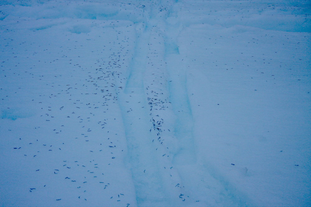
We had also installed a GPS station last February, which appears to be working just fine. So we didn't land there, but just flew by it. Imagine the surprise when we could still see the tracks that the airplane made (and even the sled tracks from hauling the batteries). These tracks were made more than nine months ago, before the southern winter. There was basically no snow fall here. At the same time, only a few kilometers away, at the top of the ridge, it has snowed about 10 m in the same time!
After a stop on Leppard Glacier to fix solar panels, we landed about 4 km away from a GPS station on land. This is used to measure the rebound of the land, as the ice load is reduced. We did a small upgrade to that station and had a late evening hike back to the plane.

Coming back to Rothera shortly before midnight we were treated with beautiful light as the sun was setting: the end of a successful day after two weeks of waiting.

Sunday, November 14, 2010

We've been stuck at the British research station, Rothera, for well over a week now, and no end of the stormy weather is in sight. Of course we are eager to get onto the glacier, but these are not the conditions to fly a plane in!


I always thought that Antarctica was supposed to be the driest, coldest, and windiest continent. I suppose the peninsula is a bit different. Windy, yes. Cold, not really (it's right around freezing most of the time). Dry, I wish. It's been snowing every day, although the snow tends to come more horizontally than vertically.

We do get the occasional clearing, but unfortunately it just hasn't lasted for more than a few hours.

Sunday, November 7, 2010

In Rothera

We're in Rothera now, a research station of about 50 people run by the British Antarctic Survey. The 5 hour trip was mostly above clouds and unremarkable, except for the lack of cabin heat. The first view of the Peninsula came only shortly before touchdown. It also revealed many layers of lenticular (lens-shaped) clouds, a reminder of the windy conditions we can expect in the field.
We were in Rothera last February, late in the Antarctic summer. It looks different now with more than 1 m of snow. The icebergs and seals add a nice touch to the scenery. Now we're getting ready to catch the first opportunity of a weather window.
The picture below shows the Dash 7 after the arrival from Punta Arenas. The same type of airplane is also used all over Greenland for passenger travel, so I was quite used to it.

Friday, November 5, 2010

On the way to the Antarctic Peninsula

We're back in Punta Arenas, Chile, from where we departed on our ship-based journey to the Antarctic Peninsula earlier this year. This trip will be shorter (we think). The goal is to dig out a weather station that has seen about 9 m of snow fall since February and to do some upgrades on other instruments we have deployed. We will fly from Punta Arenas to the British station Rothera, from where we continue by Twin Otter. Right now we're waiting for the weather to improve, so we can get to Rothera.
While waiting, Ted Scambos and I got the chance to get on board a NASA DC-8. A team of about 40 scientists and research technicians is in town as part of NASA's Operation Ice Bridge to measure changes in the ice sheets.

The DC-8 is a spacious research platform, and more importantly, it can stay in the air for more than 12 hours. That way a large part of Antarctica can be reached from South America.

The aircraft is filled with instruments: two different kinds of lasers, an ice-penetrating radar, and a gravimeter. Our flight took us straight south, then in a long arc around the South Pole, and then back to Punta Arenas, flying directly over the South Pole (I pressed the shutter a few seconds too early)

We did indeed go around the whole planet yesterday. South Pole station was well visible, even from almost 40,000 feet, but we didn't notice anybody coming out and waving at us.
The ice sheet is a huge white flat place. And yet, there are often interesting things to see. Occasionally a mountain will peak through the ice cover. In the photo below you can see sastrugi, wind ripples that are common on snow. The larger patches are areas known as megadunes (I think), with large slightly darker patches, which are regularly swept clean of new snow. The very old hardened snow reflects light differently, so they stand out.

The most beautiful part was flying over the southern tip of South America though. Tierra del Fuego is a beautiful mountainous and glaciated landscape, and it is a rare treat to see it free of clouds.


Sunday, September 12, 2010

A fall trip to Greenland

We're back in Greenland for a fall trip. The main reason for the trip is to maintain cameras and GPS stations and help them be ready for the long winter. First, Mark and I went to Ilulissat, where we study Jakobshavn Isbrae, one of the largest and fastest glaciers in the world. The weather was not great on the ice, so I don't have many photos. But here is a view of the town of Ilulissat ('City of Icebergs'). The large ice bergs in the background are grounded on a sill, which is an old moraine left behind from an icier time.


After that we left for Nuuk and Kangiata Nunata Sermia. We measured velocities at the front of this tidewater glacier by repeat-surveying of targets that were deployed by helicopter. We're used to have 24 hours of daylight when working in Greenland, but now it is late enough that it gets dark again.


Part of the work involved flying up to the ice to retrieve and service GPS stations that we deployed in April.
A look up the glacier. The faster flowing river of ice stands out clearly.

And a look out the glacier into the fjord. This is the area where Nansen arrived after the first crossing of the ice sheet. He must have been happy to see these mountains!


The front of the glacier seen from our camp:

The area around the glacier and the fjord is beautiful. Caribous also like it:


The benefit of night is the return of the aurora. We had several night of beautiful displays and also enjoyed looking at the stars, so far away from all light pollution.


Sunday, August 29, 2010

Yakutat Glacier again

In early July we headed back to Yakutat Glacier to maintain GPS instruments and do some more radar. The lower few kilometers of the glacier are about to break apart into the lake and several large ice bergs have already become loose.


Here is Joanna dragging a radar sled over the ice
Icebergs are always interesting, as they came in all sorts of shapes and sizes. Here is one with a large circular conduit from a former englacial water channel.

On the way back to Fairbanks we flew across Icy Bay, an impressive bay north of Yakutat. The glaciers there have all retreated to the end of the bay and drop very rapidly from the high mountains to the ocean. The terrain rises very rapidly from sea level all the way to the top of St. Elias at 5489 m (18008 ft) above sea level over a distance of only about 30 km; surely some of the most amazing topography on the planet.


Thursday, August 26, 2010

The International School of Blablabla

Ok, so this post comes a bit late... From 7-17 June we organized the First International University of Alaska Fairbanks McCarthy Summer School of Glaciology or the 'International School of Blablabla' as it came to be known. It was hosted at the wonderful Wrangell Mountains Center, in the old hardware store, which is a leftover of the copper mining era that came to a sudden end in the late 1930s.


McCarthy must be one of the prettiest towns in Alaska. It is one of the access points to the Wrangell-St.Elias National Park, a park the size of Switzerland. Conveniently for a glaciology summer school, it is located right at the foot of the Kennicott Glacier. From the nearby Kennicott, which was the location of the copper mining activities, one can easily access the Root Glacier and enjoy the view of the enormous Stairway Icefall.The mountain sides are host to many rock glaciers, which are ice-cored talus slopes that slowly creep out of their valleys.
We had a one-day excursion to the other side of the Root Glacier to Donohue Lake which drains every year through the bottom of the ice. There was a nice channel cut into the ice, which was now empty and would have been big enough to park a car in (if you could get it there).


Tuesday, May 25, 2010

Yakutat Glacier

I'm just back from a trip to Yakutat Glacier near the small town of Yakutat in Southeast Alaska. Yakutat Glacier has been retreating rapidly and is now in the process of loosing a large chunk of ice into a big lake. Many large rifts penetrate the ice and make it look more like the famous ice shelves in Antarctica than a glacier in Alaska.
We are documenting this retreat with cameras, but we also measure ice melt and ice velocities. Part of the program was to find the thickness of the ice. For that Andy Aschwanden and I dragged a radar across the ice surface. We found ice that was thicker than 600 m in places. This is quite impressive, because the ice surface had already dropped by about 400 m in some places during the past 100+ years.

Andy and I camped on the glacier, and once the sun was low in the sky we were surprised to find the snow surface turning black, as if covered in ash:Closer inspection revealed the source: millions of ice worms.

As soon as the wet snow started freezing, they disappeared again, digging themselves into the snow.

After the radar work we spent a few days working near the terminus and on the lake, operating from a beautiful camp site.


And finally, back in Yakutat, we stayed at a beautiful cabin on the beach and enjoyed a well-deserved beer and a camp fire.

The flight back from Yakutat to Anchorage along the coast of Southeast Alaska must be one of the most spectacular flights with a commercial jet, granting views of the most expansive ice cover in North America. First is the pancaked Malaspina Glacier with the enormous Mt. St. Elias in the background (5,400 m).

And then the beautifully sculpted Bering Glacier, the largest glacier in North America, and its big proglacial lake, Vitus Lake.

Tuesday, April 27, 2010

Glacier timelapse video

We often use cameras to document ice front positions and glacier flow. Here is an example from three months of motion at KNS. Unfortunately, the glass on the camera box got sandblasted, so the quality is not great. But isn't it fun to see the ice flow like that?


Kangiata Nunata Sermia

Kangiata Nunata Sermia is a glacier in Greenland where we just started a new study. We use KNS for short. 'Sermia' is Greenlandic and means glacier.
The glacier is at the end of a long fjord system with Greenland's capital Nuuk at the head of the fjord. The first picture is from just outside Nuuk.

The fjord landscape here is exceedingly complicated, fjords split into several arms, which sometimes rejoin. It is easy to see how one could get hopelessly lost without the help of a map and a GPS. These fjords were all carved by glaciers and the sides are often steep and have impressive walls.KNS is more than 100 km away from Nuuk. As you get closer to the glacier you can see the amount of ice retreat since the end of the Little Ice Age, some time in the 19th century. That line is quite distinct, because the newly revealed land is gray and almost void of vegetation, while the older land is covered in lichen, moss, and shrubs and appears brown. The picture below shows the line quite nicely with a distinct moraine. It also has an interesting lake that is now dammed by an old moraine. But it used to be dammed by ice (on the right side), and it is still possible to see the higher shore lines from that time.

Here is an example of a modern ice-dammed lake. These are quite common on the West side of Greenland.We set up camp near the front of the glacier on a beautiful warm day.

But then the weather turned and the next two days we only had occasional glimpses of the ice through fog, although we could here it rumble all the time.
When the weather turned nice again, we couldn't fly because the Icelanders had decided to send ash our way. But finally the weather and the ash cooperated, and we could fly again. We used helicopters to put GPS stations out on the ice to measure ice movement very precisely.
In this study we are trying to understand how the oceans eat away at the ice fronts and make the glaciers retreat. We cooperate with oceanographers from the Climate Center in Nuuk. Our job is to do glacier measurements, such as its speed and rate of advance and retreat, which can all vary seasonally. Here is a look down the glacier and out the ice covered fjord:The scale is difficult to grasp. It's a bit easier when there is a helicopter for scale. Here is a Bell 212, a helicopter big enough for 9 passengers and 2 pilots:

Can you still see it?The ice near the glacier front is just a jumbled mess, and it is near impossible to tell where the glacier ends and where the ocean starts. That's not so uncommon in late winter, and I expect things to clear out quite a bit in summer.


Sometimes one can find patches of ocean water near the glacier's front.
For now we're done putting out instruments. Let's hope it's all working, so we have lots of good data when we return in late summer. Stay tuned.