
Thursday, November 15, 2012
Waiting for weather
Pretty soon, hopefully, we'll be out of email contact for several weeks. At the moment we are waiting in McMurdo for a flight to Wais Divide and then on to the PIG (Pine Island Glacier). Yesterday we tried. After a 3 hour flight, we circled for two more hours trying to land. But the weather just wouldn't clear. At 3 AM we were back after 8.5 hours in the air. Gruesome.
 The scale of this undertaking is quite daunting. The distance from McMurdo to PIG is about 2,400 km. That's similar to the distance from Seattle to the Twin Cities, or Madrid to Oslo. The flight will actually carry us across the date line, but we will probably not adjust our time to stay synchronized with McMurdo. We have 24 hours of sunlight now, so it doesn't matter too much.
Wednesday, November 14, 2012
The migration to the South
I feel like the Arctic Tern that migrates from the Arctic summer all the way to the Antarctic every year. Although the birds do it under their own power, while I got here through a long and complicated series of flights: Fairbanks - Seattle - Los Angeles - Sydney (in an Airbus A-380) - Christchurch (New Zealand).
In Christchurch we get outfitted with cold weather gear and then on to McMurdo (Antarctica) via military transport with a C-17.
Christchurch suffered a terrible sequence of earthquakes, the most damaging of which killed over 100 people about 2.5 years ago. Downtown Christchurch is still mostly inaccessible, and buildings that are structurally damaged are still being demolished, before new ones can go up. After all this time, lots of the damage is still obvious and it will take a long time until things are entirely back to normal. The city still experiences after shocks, but they have now gotten less powerful and people are hoping that the worst is over. Once in McMurdo, we go through a series of training, and then it's out to the field site. We are trying to get to Pine Island Glacier (known as PIG). The transport is by military C-130 Hercules airplanes. These are the only Herc's that operate on skis and can land way out on the Antarctic Ice Sheet. They are also the main way of supplying fuel to South Pole Station. Currently we are waiting for weather on the ice to improve, so we can get out and start drilling. We are planning to drill a hole through the PIG ice shelf and put instruments in the ocean underneath to quantify the amount of melting.
 |
| A high rise building in Christchurch is being demolished |
Christchurch suffered a terrible sequence of earthquakes, the most damaging of which killed over 100 people about 2.5 years ago. Downtown Christchurch is still mostly inaccessible, and buildings that are structurally damaged are still being demolished, before new ones can go up. After all this time, lots of the damage is still obvious and it will take a long time until things are entirely back to normal. The city still experiences after shocks, but they have now gotten less powerful and people are hoping that the worst is over. Once in McMurdo, we go through a series of training, and then it's out to the field site. We are trying to get to Pine Island Glacier (known as PIG). The transport is by military C-130 Hercules airplanes. These are the only Herc's that operate on skis and can land way out on the Antarctic Ice Sheet. They are also the main way of supplying fuel to South Pole Station. Currently we are waiting for weather on the ice to improve, so we can get out and start drilling. We are planning to drill a hole through the PIG ice shelf and put instruments in the ocean underneath to quantify the amount of melting.
 |
| The C130 Herc airplane on wheel-skis on a sea ice runway |
 |
| Dale is ready to drill, but we have to wait for better weather on the ice |
Thursday, September 13, 2012
LeConte Glacier
This fall I had an opportunity to go back to LeConte Glacier in Southeast Alaska. LeConte Glacier can be accessed from the fishing town of Petersburg, which was founded by Norwegian fishermen, supposedly because of the ready availability of glacier ice for cooling.
LeConte Glacier is the southernmost tidewater glacier in the northern hemisphere. I have been lucky to be able to go to some of the more spectacular places on Earth (at least as far as ice goes), but LeConte might trump them all.
LeConte Glacier comes out of the Stikine Icefield, which hosts some spectacular peaks. Most notable is Devils Thumb, which features in Jon Krakauer's book 'Into the Wild'. It is a notoriously difficult climb, because it is exposed to so much bad weather.
The spectacular scenery here comes at a price, and rainy and cold days are the rule.


The reason for our work lies in the fact that LeConte Glacier was the site where a study by Roman Motyka has found that significant amounts of melting occur at the base of the glacier by warm ocean water. We have wanted to follow up this 2003 study for many years, but have been unsuccessful with funding. Due to a recent generous grant from the Gordon and Betty Moore Foundation, we were finally able to repeat this interesting work.
While one crew was doing oceanography off a small boat, we were at a camp, measuring ice flow with a fancy new radar, and recording calving with timelapse photography.


 |
| Sea lions relaxing in Petersburg's harbor |
 |
| At the entrance of LeConte Bay |
 |
| LeConte Glacier, at the head of a narrow fjord |
 |
| The glacier from our camp site |
 |
| LeConte Glacier with Devils Thumb |


The reason for our work lies in the fact that LeConte Glacier was the site where a study by Roman Motyka has found that significant amounts of melting occur at the base of the glacier by warm ocean water. We have wanted to follow up this 2003 study for many years, but have been unsuccessful with funding. Due to a recent generous grant from the Gordon and Betty Moore Foundation, we were finally able to repeat this interesting work.
 |
| The boat, lost among ice bergs |


 |
| Some glacial geology: Striations carved into the bedrock by the glacier |
Monday, September 3, 2012
It's winter on Black Rapids Glacier
Lee and I wrapped up a successful season on Black Rapids Glacier. We removed all summer instrumentation and beefed up the three GPS that are staying for the winter with high capacity batteries.
The trip started with bad weather and new snow on the glacier, but it quickly turned into beautiful fall weather. But there is no mistaking it: winter is on the way, and a thin layer of fresh powder was coating the surface.


A view of the landslides that hit the glacier during the November 2002 Denali Fault earthquake. The coating of rocks insulates the ice from most melt. The clean ice continues to melt, however, resulting in an increasing height difference between ice and rock.


A view of the landslides that hit the glacier during the November 2002 Denali Fault earthquake. The coating of rocks insulates the ice from most melt. The clean ice continues to melt, however, resulting in an increasing height difference between ice and rock.

Saturday, August 18, 2012
Pulling out of Nuuk
For the past three years we had an NSF funded study to look at ice-ocean interaction in the Nuuk fjords. This is the final year, and last week we had to pull all our equipment of the glacier. This consisted of a series of GPS receivers, seismic equipment and some cameras. Some of this equipment has operated year-round and needed quite a bit of battery power. All in all, we moved about 2,000 kg of material back.
Nuuk is
the capital of Greenland, and by far the biggest town. While the small
settlements all around Greenland are slowly dwindling, Nuuk grows at an
incredible pace. It has a good harbor, but the site for the town was
chosen before the advent of airplanes, and access by air is hampered by
frequent fog, heavy cross wind, and the topography, which only allows for a very short
runway, which is serviced by relatively small Dash-7 (nowadays Dash-8)
aircraft.
The main glacier entering the fjord system is Kangiata Nunata Sermia. In summer it often has a small area in front of the ice where dirty subglacial water upwells, bringing lots of nutrients with it. The birds love it and frequently feed there.
 Some of the water entering the fjords come from the numerous ice marginal lakes that frequently drain under the ice. This one, at KNS, was first reported on by Nansen. He walked off the ice sheet at this location after the first documented crossing.
This ice-marginal lake at Narssap Sermia is huge. It drains every few years. As the glacier is thinning, lake drainages are likely to become more frequent, but perhaps also not as large. This one drained subglacially a few years ago. When the fresh water rose to the surface of the ocean, it carried many redfish with it. The sudden pressure change killed many of them and they were found belly-up.

The fjord was also popular for native and old Norse settlements. The Norse lived in Greenland for several centuries and somewhat mysteriously disappeared when the climate turned less favorable. Many sites still show rock walls and traces of settlements that can be traced to them.
Nowadays, there is only one small settlement in the fjord: Kapissillit. It can be reached year-round, because it is situated in a protected fjord that often does not have heavy sea ice.


 |
| Nuuk, Greenland's capital |
 |
| Nuuk's short runway |
 |
| We used an Air Greenland Bell 212 to remove our survey equipment |
The main glacier entering the fjord system is Kangiata Nunata Sermia. In summer it often has a small area in front of the ice where dirty subglacial water upwells, bringing lots of nutrients with it. The birds love it and frequently feed there.
 | |
 |
| The small dots over the water are hundreds of birds looking for a meal |
 Some of the water entering the fjords come from the numerous ice marginal lakes that frequently drain under the ice. This one, at KNS, was first reported on by Nansen. He walked off the ice sheet at this location after the first documented crossing.

The fjord was also popular for native and old Norse settlements. The Norse lived in Greenland for several centuries and somewhat mysteriously disappeared when the climate turned less favorable. Many sites still show rock walls and traces of settlements that can be traced to them.
 |
| Norse ruins in the ice fjord |


Friday, August 10, 2012
Jakobshavn Isbrae, Greenland
I'm back in Greenland for two different project. First we went to Ilulissat on the West Coast to use a new ground based radar for measuring the speed of the world's fastest glacier: Jakobshavn Isbrae. The glacier continues to retreat and is now as far back as it has been since observations started. It is also flowing very fast, with speeds exceeding 50 meters per day at the front.


 One thing we are interested in is how the speed of the glacier changes when it calves into the ocean. In the field, we run cameras at high intervals (10 seconds) to capture calving events. In past years, these events have been dramatic. Now they seem to be smaller, but much more frequent. Here is one calving event. The light is a bit low, since it happened at 2 AM.
 |
| Ilulissat on a nice evening |
 |
| Ilulissat: City of icebergs |

 |
| Our camp on recently deglaciated land |
 |
| Not much lives here, but we do get an occasional visitor |

 |
| Gamma Remote Sensing's ground based radar |


Sunday, July 29, 2012
Black Rapids in summer
In all my years in Alaska I've spent about half a year on Black Rapids Glacier, but never in summer! So it was a new thing for me to be camped there on ice. We had a very quick trip, just two days to check in on all our instruments.
Since we've installed GPS stations in April, all the snow and quite a bit of ice has melted. The antennas that were originally at the surface were now sticking up by almost 3 m. We put them near the surface again, so they would be more stable.


One of the goals of this project is to measure how lake drainages affect the flow of the glacier, particularly in the area where the two main tributaries meet. Below is a timelapse sequence of the slow filling and rapid drainage of one ice marginal lake.
Since we've installed GPS stations in April, all the snow and quite a bit of ice has melted. The antennas that were originally at the surface were now sticking up by almost 3 m. We put them near the surface again, so they would be more stable.
 |


Black Rapids was exposed to several really large landslides during the Denali Fault earthquake of 2002. The debris protects the glacier from melting, so every year, the rock covered ice stands out more, as the uncovered ice continues to melt. This also leads to the formation of lakes that occasionally drain.


One of the goals of this project is to measure how lake drainages affect the flow of the glacier, particularly in the area where the two main tributaries meet. Below is a timelapse sequence of the slow filling and rapid drainage of one ice marginal lake.
McCarthy summer school
Darn, just accidentally deleted this post. I'll try to recreate from the last saved draft...
The pictures are from the 2nd UAF International Summer School in Glaciology held in McCarthy in June. During that time I also had a chance to do some airborne radio echo sounding on the Harding Icefield.


The pictures are from the 2nd UAF International Summer School in Glaciology held in McCarthy in June. During that time I also had a chance to do some airborne radio echo sounding on the Harding Icefield.
 |
| Old surge moraines: Black Rapids Glacier |
 |
| The beautiful Wrangell volcanoes |
 |
| Hiking near Kennicott: Ed, Regine, Sonja |
 |
| McCarthy: The Mekka of rock glaciers |
 |
| Sonja on the Root Glacier |
 |
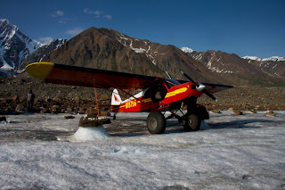
| Ultima Thule Lodge. Lodge owner Paul Claus does a lot of our glacier flying |
 |
| Prince William Sound: On the way to the Harding Icefield |

 |
| Harding Icefield on the Kenai Peninsula |


 |
| McCarthy |

 |
| The old Hardware Store: our classroom |

 |
| Summer school participants were camping |

 |
| Some old mining buildings in McCarthy |


 |
| Sonja: the youngest summer school participant |


Subscribe to:
Posts (Atom)