Tuesday, July 9, 2013

Black Rapids lake drainage

This was a quick trip for me to help set up some surveying instruments on Black Rapids Glacier. We were here to watch the effect of a draining lake. From past measurements we know that the glacier can start flowing 2-4 times faster when water reaches the base. We wanted to see whether such a speed-up can also draw in ice from a big tributary glacier.

Aurora Lake, full to the brim, and ready to drain. This is the biggest of the marginal lakes.
The upper Black Rapids Glacier has many of these potholes, old crevasses that often fill with water and then drain.

Looking up Black Rapids Glacier
Mt. McGinnis

Our surveying equipment: An automatic theodolite and a precise radar that allows us to measure deformation fields in the entire field of view.


While checking out various instruments, we had an opportunity to hike around the glacier. It's always nice to see the signs of life in the harsh conditions of the mountains.
A plugged up moulin; this hole leads right to the bottom of the glacier!

A ptarmigan nest ...

... and mama ptarmigan whom I inadvertently chased off her nest.

A panorama showing the Loket tributary as it enters the main valley of Black Rapids.
I recorded this video as I hiked out the glacier. Near the glacier front, water comes up from underneath the glacier and creates these big waves.

Sunday, June 9, 2013

The Stikine Icefield

Part of our recent survey took us down to the Stikine Icefield, Alaska's southernmost icefield. Its southern location and relatively low elevation make it vulnerable to changing climate, but this can be offset by high rates of snowfall. The icefield has several glaciers that reach the ocean, among them LeConte Glacier, the southernmost tidewater glacier in the northern hemisphere. Many of the tidewater glaciers have retreated very rapidly in the past few years.

The icefield is spectacular with many impressive spires, most famously Devil's Thumb.

Sawyer Glacier calving into a very narrow fjord

The famous Devil's Thumb with Cat's Ears and Witches Tit to the right.

Devils Thumb through a gap

Witches Cauldron: This is a really weird place where glaciers flow in from several sides and just kind of disappear. It's where glaciers go to die...

Devil's Thumb with shadows of the Cat's Ears

Burkett's Needle

The picturesque fishing town of Petersburg

What are you looking at?


Dawes Glacier (I think). The trimlines show the extent of recent ice loss

A cruise ship in Tracy Arm

Friday, June 7, 2013

Surging glaciers

While we were surveying glaciers in several mountain ranges, we had the opportunity to watch a vast variety of glaciers. While many are rapidly retreating, some are advancing and a few are experiencing a glacier surge. This is a phenomenon where a glacier increases its speed by a factor of ten or more for several months. It only happens on very few glaciers. Glacier surges happen periodically, every few years on some coastal glaciers and every few decades in the Alaska Range. So it's always a special treat to see one.

Turner Glacier (coming straight at us, across the bay) is the only tidewater glacier in Alaska that is surging. It has an unusually quick repeat cycle and this is its third surge in the last ten years.

The broken surface of Turner Glacier near its front

We noticed unusual crevasses on the Logan Glacier in March, and now they are even more pronounced.

The surge does not produce crevasses across the entire glacier, but there are distinct crevassed bulges on the side that indicate fast flow.

Logan Glacier

This is the Robertson or the Johnson Glacier in the Alaska Range. It is not known to surge, and I don't believe this is a real surge. But that fresh shear crevasse running along several kilometers is something I've never seen before on a glacier.


Monday, June 3, 2013

Avalanches

One of the amazing things on this last trip was the very large number of avalanches that we saw, wherever we went. There were avalanches in each mountain range and at every exposition. Some of them with run-outs like I've never seen before.

Everything has slid here.

Individual snow rafts seem to glide well into the flat parts with very little friction. They look more like mudslides.

Amazingly long run out (it continues well into the shadow)

Look at the crown on the one on the left. We estimated it at well over 5 m!

An avalanche with crevasses? That says something about how active the glaciers are.

Sunday, June 2, 2013

Airborne surveys in Alaska

We spent a wonderful two weeks at Ultima Thule Lodge in the Wrangell St.Elias mountains. Our goal was to do airborne glacier surveys all over Alaska. We run LiDAR surveys to measure how glaciers change over time and radar surveys to measure how thick they are. The program did not start well. Interior Alaska experienced one of the coldest springs ever recorded and the mountain weather was not very conducive to flying. But by the second week it warmed up and the weather finally cleared. Within just a few days I got to see some amazing mountains. Sometimes I think that by now I've seen a lot of the mountains of Alaska, but this trip showed me (again), that there is still so much more to see and do. Below is a selection of somewhat random pictures; I took more pictures on this trip than on any previous field trip ...

The Root Glacier near McCarthy with the stairway ice fall in the background. This is one of the largest ice falls in the world.


Paul Claus's Single Otter

A medial moraine

The beautiful moraines of the Kaskawulsh Glacier in Kluane National Park

Mt. St.Elias, at over 5,400 m one of North America's tallest mountains. In the foreground Malaspina Glacier

The beautiful sand beach by Yakutat and Mt. Fairweather in the background.

The front of Hubbard Glacier, North America's longest tidewater glacier, and one of only a handful of advancing glaciers.

Looking almost 100 km down the Fairweather Fault (the extension of the San Andreas Fault). In the background is Mt. Fairweather.

Hubbard Glacier and Gilbert Point. The healthily advancing glacier is threatening to build an ice dam at this location. It has happened twice already, in 1986 and again in 2002.

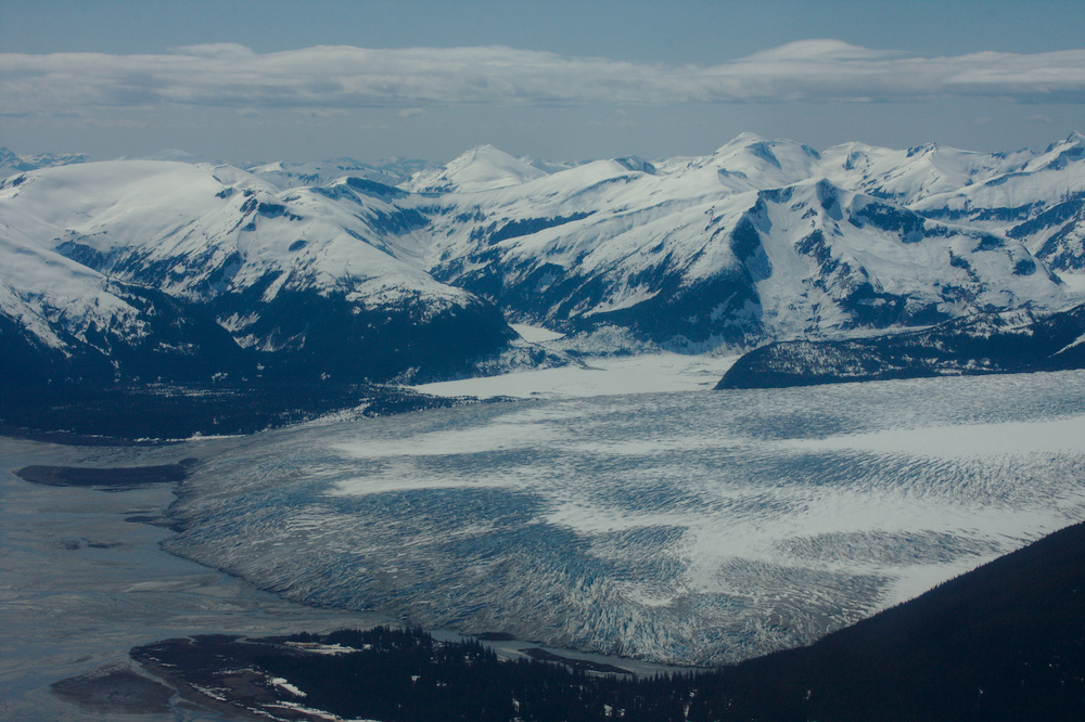
The fronts of Logan and Chitina Glaciers

The alien landing site: A glacier sinkhole.

Mt. Logan is a massive mountain. It is just short of 6000 m high, and quite possibly the most massive mountain on Earth.

Hole in the Wall Glacier: This is an overflow of another advancing glacier: Taku Glacier in the Juneau Icefield. This glacier did not even exist 150 years ago!

Taku Glacier

Monday, April 29, 2013

Cold spring on Black Rapids Glacier

We're just back from an April trip to Black Rapids Glacier. Usually this is a pretty enjoyable and warm time of the year with nice spring snow. This year turned out to be mostly cold and windy, but the weather was still quite beautiful. In fact, interior Alaska is experiencing one of the coldest Aprils on record.

We set up some GPS stations to measure the ice flow in an area where the glacier is met by a large tributary. We'll be watching how the tributary reacts when the main branch speeds up during times of draining lakes. We are also interested in the shape of the glacier bed, so we did a lot of radar measurements. This works by sending a low frequency radar wave through the 500-600 m thick ice and measuring the time it takes it to return to the surface.

Camp put-in with Paul Claus and the very capable Ultima Thule Single Otter

Camp in the Lokket tributary

Camp from a bit further away

Lee is checking the radar receiver to make sure it is working properly

The impressive south face of Mt. McGinnis

Mt. Silvertip across the Delta River valley

Chris looking lost in a white-out

Looking down on the 'potholes'. These holes fill with water in the summer and when they drain to the base, the glacier speeds up. We set up cameras to watch them fill and drain.

Christie climbing to one of the camera locations