In the 1960s one of my glaciological heroes, Charlie Raymond, did his PhD work on Athabasca Glacier in Jasper National Park. He figured out how the motion at the base of the glacier is distributed. This is now textbook material. We were interested in finding out how this has changed in the meantime. The glacier is now 50 m thinner, so it is basically a different glacier in the same setting. We spent most of the month of July drilling 12 holes to the bottom of the glacier and putting instruments in the holes to measure the deformation of the ice and the water pressure and electric conductivity at the bottom of the hole.
 |
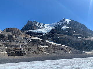
| View of the Athabasca Glacier as it flows down from the Columbia Icefield |
|
|
 |
The hotwater drill set up. We heat up this water and then pump it into a hose to melt holes through about 200 m of ice.
|
 |
Most of the material was flown up with helicopters, but we did have to haul up a spare heater. I put the picture in black and white, because it reminded me a bit of the methods of the Scott expedition.
|
 |
Lots of melting and supraglacial rivers that eventually disappear into moulins
|
 |
In addition to the borehole work we also put up several GPS stations to measure the flow of the ice
|
 |
This glacier is a bit of a crazy place. Due to the proximity of the Icefield Parkway, it is amongst the world's most visited glaciers. One way to get on the glacier is on these big tired glacier buses (one of which is used by the US program in Antarctica) to drive right up on the ice.
|
 |
David is checking on his borehole instruments
|
 |
We also set up a radar to measure glacier velocities
|


