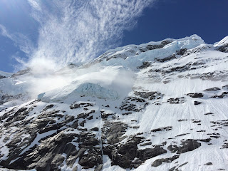
One thing about doing field work in Antarctica is that, when you think you're all done, you have upwards of a week just to get home. Two days ago we got off the ship in Punta Arenas, Chile, and now we are on the way back to Alaska. One small perk of this long flight is that we happened to fly on one of those rare good weather days and I had a window seat. So here are some pictures of the Southern Patagonian Icefield:
Wednesday, December 30, 2015
Monday, December 14, 2015
Some impressions of Andvord Bay and Gerlache Strait
Recently we've had some amazing weather, so the true beauty of this area was revealed. We worked all night yesterday, fixing a weather station and retrieving an autonomous glider that's been going up and down the water for the last several days. Below are a few pictures from that glorious night.
 |
| Anvers Island |
 |
| The obligatory Gentoo Penguin |
 |
| And for the fluid dynamics geek: Probably the most beautiful example of a Kelvin-Helmholtz instability that I've come across |
Monday, December 7, 2015
One more glacier camera
Yesterday we installed the second glacier camera for this project. The day could not have been more different. Instead of sunshine we had almost continuous downpour. We did find a nice site though, under slightly overhanging bedrock, which affords us with a nice view of the other fjord arm.
 |
| View of the Laurence M Gould from our camera site. |
 |
| View into the fjord |
Saturday, December 5, 2015
Glacier timelapse
We put up a glacier timelapse camera today. That was a pretty spectacular undertaking, because the fjord walls here are so steep with many hanging glaciers and big cornices. We found one ridge that is safe and successfully installed a camera today. We got lucky with weather, this was the first blue sky day since we've left Punta Arenas.
 |
| Hanging glaciers on steep fjord walls |
 |
| The LM Gould from our camera site |
 |
| The glacier camera |
 |
| ... and two happy oceanographers, on land for once |
Wednesday, December 2, 2015
Oceanographic moorings
As part of this project we put in several oceanographic moorings to measure various physical parameters over the next one and a half years. The moorings consist of a railroad wheel that acts as an anchor, an acoustic release, various instruments to measure things like salinity, temperature and water flow, and a big submerged buoy to avoid the ice bergs on top. Deploying such moorings in waters full of ice is quite exciting, and we're happy that it all went well. Now we hope all instruments are recording, so that at the end of the next Antarctic summer we can recover and download the instruments.
 |
| The mooring team (plus me who gave moral support) |
 |
| Some nice wind clouds |
 |
| Penguins on an ice berg |
 |
| Putting the mooring together, as it is lowered into the ocean, piece by piece |
 |
| A nice sun-lit ice berg |
 |
| Detail of a highly crevassed ice berg |
Tuesday, November 24, 2015
Arrived at Palmer Station
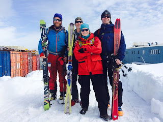
We arrived at Palmer station where the ship will remain for two days to offload some passengers and cargo. We took this opportunity to break out our skis and climbing gear and visit the local glacier, which consists only of a small icecap.
 |
| Palmer Station |
 |
| A nice blue iceberg in the Neumayer Channel, near Palmer Station |
 |
| Team 'Terrific' goes skiing .... |
On the way to the Antarctic Peninsula
We are starting a new research program on the western Antarctic Peninsula, looking at the biological productivity in glacial fjords. It brings me back to a place we visited almost 6 years ago with spectacular scenery, lots of wildlife, and beautiful glaciers. But getting to the Peninsula means crossing the famous Drake Passage with its storms and big seas on an icebreaker. Luckily for us, the crossing turned out to be relatively calm, and we are now heading for Palmer Station to offload some gear and passengers. After that we'll be on the ship (the Laurence M Gould) for about a month doing mostly oceanography and putting out some timelapse cameras and weather stations.
 |
| Leaving Punta Arenas (Chile) with one day delay. |
 |
| Our first snow storm |
 |
| ... and our first big ice bergs, just before it got dark. |
Tuesday, October 20, 2015
One more rainy trip to Taku Glacier
This year I wasn't so lucky with weather on Taku Glacier. Our fall trip was a wet one again. But the good news is that instruments were working and we got everything ready for winter. However, we had to camp out an additional day, because it was so foggy that the helicopter couldn't make it to the glacier.
Thursday, September 3, 2015
Operation IceBridge Alaska, Fall 2015
Each year in May and again in August we fly over many of Alaska's glaciers to measure how much they change and recently we are also measuring ice thickness with an airborne radar. The surface measurements have happened for over 20 years, started by Keith Echelmeyer and continued by Chris Larsen.
These flights give us a unique opportunity to see the large variety of glaciers that Alaska has and the measurements document how dramatically they change.
 |
| The survey plane is a DHC-2 Single Otter; the perfect airplane for the remote mountains of Alaska. |
 |
| We base our operations out of Ultima Thule Lodge, operated by the family of Paul Claus, the skilled pilot of the Single Otter |
 |
| The western margin Bering Glacier calving into a lake |
 |
| Parts of Bering Glacier have become so stagnant that a forest is growing on top of the ice |
 |
| A forest with crevasses, how strange is that? |
 |
| This is a landslide on the Bagley Ice Field. The debris has been distorted by glacier flow |
 |
| This is a fresh landslide, also on the Bagley Ice Field |
 |
| The mighty Mt. Logan behind the massive Bagley Ice Valley |
 |
| In late summer much of the snow is gone from the glaciers and all the distorted layers in the ice become visible. |
 |
| The glaciers in the Chugach Mountains are not looking very healthy. Many of them have almost no snow left at the end of the summer, even at their highest elevations. |
 |
| Here is a healthy glacier for a change: Yahtse Glacier in Icy Bay is steadily advancing. |
 |
| Icy Bay is truly one of the world's most spectacular places. This magnificent water fall was only just revealed by the retreating ice. |
 |
| Another example of a remnant glacier that doesn't have long to live. |
 |
| A close-up of the Sherman Glacier surface |
 |
| Rock glacier |
 |
| The Alaska Range on the way home. During the past two weeks the mountains have changed from late summer to early winter. |
Monday, August 17, 2015
Taku Glacier drilling
We just got back from Taku Glacier, one of the few remaining advancing glaciers in the world, where we study the motion of the glacier, both ice deformation and how it moves over the bottom; and how this changes seasonally. We also look at how the glacier deforms proglacial sediments and erodes its base. To do this, we use a whole range of glaciological measurements, including surveys with GPS, radar, active and passive seismics, borehole invetigations, timelapse cameras, stream measurements and dye tracing tests. All of this activity sure made for an interesting field camp with up to 13 people there at times.
Below some pictures from the field work in no particular order.
Below some pictures from the field work in no particular order.
 |
| Chris and Dale and I are installing a new instrument we developed: an instrumented subglacial dragspool that measures ice and till deformation, water pressures and sliding of ice over till. |
 |
| The drill camp on a nice day. |
 |
| A moulin that conducts water from the surface to the bottom of the glacier. |
 |
| The daily commute from the drill site to the camp at the front of the glacier. |
 |
| A nice evening at camp. |
 |
| Near the glacier front. |
 |
| Looking out over the Taku River and Taku Inlet. Everything in this image was at least 100 m deep ocean about 100 years ago. |
 |
| The glacier terminus. |
 |
| The main glacier outflow on the eastern glacier side. |
 |
| The glacier terminus. |
 |
| The glacier advances in winter and spring and then retreats in the summer because of the very high melt rates, leaving push moraines behind. |
 |
| Here the glacier advanced across the Norris River last winter and has now retreated again. |
 |
| Taku Glacier used to calve into tidewater. Now the only calving happens into a small section of the Norris River. |
 |
| Two ice marginal lakes on the Norris River drained while we were in the field. We noticed the very high stage of the river and got to see the cause on the flight back to Juneau. |
Subscribe to:
Comments (Atom)


