Monday, December 10, 2018

Patagonia

A few weeks I had an opportunity to join some Japanese colleagues for field work in Patagonia. I have long been interested in this area, and it is fantastic to make this connection with researchers from Hokkaido's Institute of Low Temperature Science. They have a long history of investigation in Patagonia. I am particularly fascinated by the lake-calving glaciers on the Argentinian side, because they are quite different from those we have in Alaska.

The field team, including my Japanese host, Masahiro Minowa, and the grand old glaciologist of Argentina, Pedro Skvarca.


On the way to Upsala Glacier. This glacier has retreated dramatically in the past few years and until recently it was not even possible to approach the glacier because of the quantity of ice on the lake.

CTD measurements by hand take a long time in water that is over 500 m deep. We also deployed a mooring that we hope to recover in March 2020. It will be the first such measurements near Glaciar Upsala.

We also installed a timelapse camera near Upsala.

This is the view from the camera.

And our boat, operated by the Argentinian coast guard.

Beautiful glacially carved and recently exposed rock.

Patagonia is the land of wind and this cloud is showing that it is starting to blow hard again

We also did some glacier GPS surveys on Perito Moreno Glacier.


Perito Moreno from our base camp

This is the view from our Perito Moreno camera site. This glacier is intriguing, because unlike other Patagonia glaciers, it is not (yet) retreating. In fact it annually advances against the point in the picture and sometimes temporarily dams one branch of Lago Argentino, leading to dramatic outburst floods.


Condor over Glaciar Perito Moreno

NASA video of Operation IceBridge Alaska

Here is a nice video that NASA produced and that highlights some of our work. It takes a keen eye, but I do actually appear in here as well :)


Tuesday, November 6, 2018

Columbia Glacier

This is a cool comparison of photos by Austin Johnson from our August flights. It shows the impressive retreat of Columbia Glacier Click here for the animated version, in which you can slide between the two images.

Monday, September 24, 2018

Muldrow Glacier surge

National Park geologist Mike Loso had noticed a while ago that the Muldrow Glacier north of Denali was showing signs of surging. My colleague Mark Fahnestock started tracking it on satellite imagery and he had figured out that one tributary had been flowing much faster than normal. Last weekend we had an amazing fall day, so I got a chance to fly my whole family down and check it out.

This is the remote sensing analysis. The fastest part is in the Traleika tributary (over 3 m/d) but the fast flow continues into the main branch of the glacier.


 Here are some pictures:

Denali is an imposing presence, even from a long distance

Muldrow Glacier. The Traleika tributary is the second one entering the glacier from the South (left in this picture)

Traleika tributary junction

Looking up the Traleika with extensive crevassing.

The rapid flow causes chaotic shear margins

The upper Traleika Glacier

Some small tributaries seem to have become engaged in the surge

Shear margin


Looking downstream from the Traleika into the main branch of the Muldrow. The Traleika branch is most obviously affected by the surge, but fast flow clearly extends down the main branch, as indicated by the flow speeds.

The glacier tributary junction. Note the crevassing below the junction.

Mt. Foraker

Sunday, September 23, 2018

OIB-AK: a few more impressions

Below are a few more pictures from our fall campaign.

A glacier-dammed lake on the margin of Bering Glacier

A small glacier in the Chugach Mountains. Many of these glaciers have almost no snow left in the fall and will soon be completely gone


A lake-calving glacier in the Chugach Mountains


College Fjord

Saturday, September 22, 2018

The Yakutat Icefield

One important target this year was the Yakutat Icefield. This is one of the most rapidly changing glaciated areas in Alaska. All of the glaciers are at quite low elevation, and the icefield will most likely disappear within this century. We published a paper a few years ago that showed that even without further warming, the icefield is essentially doomed.

Here is a prediction that we made in 2013:

This is a map view of the Yakutat Glacier, which is part of the icefield. Colors indicate ice thickness with red being the thickest ice (around 600 m). The lake is shown in white. The retreat we had predicted by 2020 has almost happened already. Below  is a picture from the eastern margin (right terminus above). The two tributaries still join, but probably not for much longer.


And here is the western terminus. Again, as predicted, the two tributaries still join, but just barely.


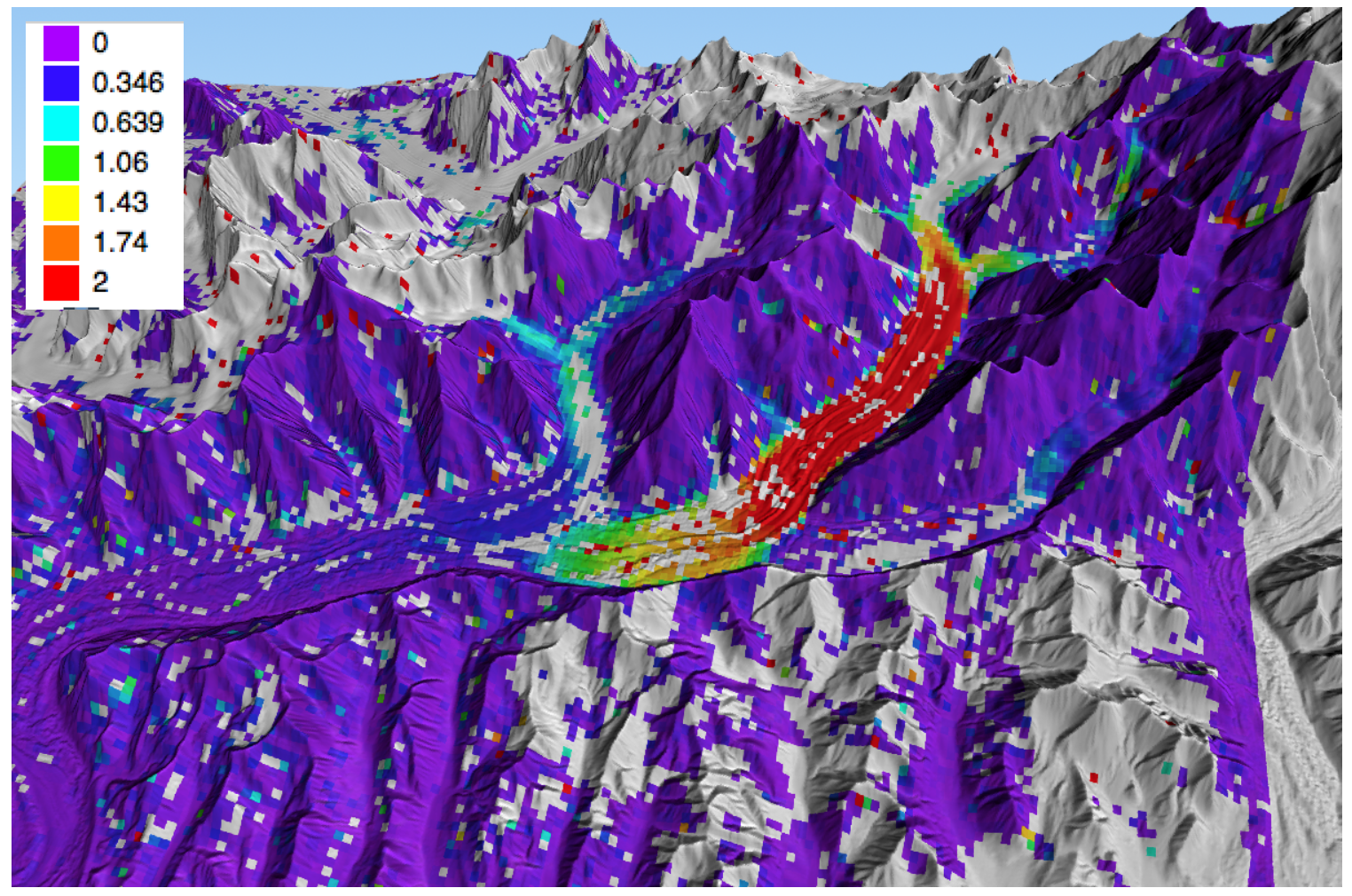
The reason for this rapid retreat is that even the highest elevations on the icefield are just at about 600 m asl, which is quite low. So all the snow melts, even at the higher elevations, as seen in this image:


The melting slowly uncovers previous years snow accumulation. It is like cutting through a layered cake and it shows the patterns of past snow accumulation.


Some other pictures:


Even the top of the mountains don't have any snow left in late summer
A beautiful example of wave ogives: Bulges that form each year at the bottom of some ice falls.
An ice marginal lake drained here. The water was released in a flood under the glacier. The stranded ice bergs on the side indicate how big the lake was.
  
Some floating ice bergs in the proglacial lake.
Mt. Fairweather in the distance


On the way back we passed by Hubbard Glacier. It is an advancing tidewater glacier and it is threatening to separate the two branches of the fjord visible in the picture. This would turn Russell Fjord (on the left) into a lake.


Friday, September 21, 2018

OIB Alaska Fall 2018: Icy Bay

The second annual campaign of OIB-Alaska happened in August. In a pattern that has become quite common, we were able to gather a lot of lidar and radar data in just a few long days that were interrupted by bad weather. This August was particularly rainy; one of the wettest on record in interior Alaska with some unusually heavy downpours.

We started the fall campaign with a survey of Icy Bay. This is an incredible place with some of the steepest mountains in the world (Mt. St.Elias rises straight out of the ocean and extends to over 5400 m). The combination of ocean, huge mountains and very active glaciers is simply awe inspiring. Below are some impressions:

This is Mt.St.Elias and in the foreground is the bay in front of Tyndall Glacier. A rockfall led to a huge tsunami a few years ago. The tsunami scars are clearly visible along the sides and most of the island in the foreground was swept clear of all vegetation.

This is the other arm of Icy Bay. All of the water in this and the previous picture was glacier covered a hundred years ago.

The Yahtse Glacier is now readvancing.

Icy Bay is full of spectacular water falls


... and some amazing geology.


This is an disintegrating dirty ice berg. This is how glacial material slowly covers proglacial fjord bottoms

Moraine pattern on the nearby Malaspina Glacier

The Malaspina Glacier is rapidly thinning and retreating into a series of proglacial lakes. Some of these lake are only barely separated from the ocean.


A drained lake that formed on top of debris-covered ice

Overview of Icy Bay on the way home.